)
I was wide awake at 3 a.m. I had begun to think more seriously about our return trip, and I was worried about our connection in Honolulu on Friday. I had purchased tickets for the first available flight from Kapalua to Honolulu. The tickets for the trip to the mainland specified a departure time from Honolulu of 3:35 p.m. That would have given us plenty of time, not just to catch the plane but to eat lunch in the airport. However, in November I had received an email from Delta noting that the flight's times had changed. The new time of departure was 11:05, which I feared was cutting it too close for comfort.
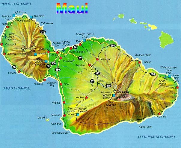
I discovered on the web that there were several flights from Maui's main airport at Kahului to Honolulu with earlier departure times than our current one of 9:36. Perhaps, I thought, we could arrange to return the rental car to the Kahului airport instead of the Kapalua office and book passage on one of those flights. I would need to see what Sue thought.
I spent an hour or two going over the stops that I planned on the trip around the West Maui Mountains. No one would be in the navigator's seat, and so I needed to construct a one-page outline that listed mile markers — something that I could quickly access without pulling over. I also planned to bring the guidebook that had descriptions of every aspect of the circular journey. I planned to consult it when I had found parking places.
When Sue awoke I discussed my concerns about the connection with her. She called Budget. They told her that it would cost us $150 extra to return the car to Kahului. We would probably also need to pay Hawaiian Airlines to change our plane tickets.
)
Sue then called Delta. The lady there had a difficult time understanding what her issue was, but she eventually checked something on the computer and assured Sue that according to her records we would have enough time to make the connection. However, I suspected that the Delta agent was probably no more familiar with the Honolulu airport than I was. My experience was that the ease of getting from one section of an airport to another varied greatly from one airport to another. I still felt anxious, but we decided not to change our tickets. I know; hope is not a plan.
)
Still nothing from Moloka'i. It was official; a trip there was no longer under consideration.
For breakfast I returned to my original choice of scrambled eggs, bacon, and toast. It was so nice to eat breakfast in this relaxed convenient location. Sue and I were both very glad that we were able to stay at the Plantation Inn.
)
After breakfast I went down to the car. I was about to press the start button when I realized that I had forgotten my camera. I had suffered from “paradise paralysis” before, but this was a new low. I retrieved my camera and returned to the Rogue. I started the car and exited from the garage onto Panaewa Street. As the car turned onto Lahainaluna Road, I realized that I did not have my phone. Did I really need it? I wanted to be able to call Sue when I was heading back to the hotel. Also, in 2018 it would be foolhardy indeed to set off on my own with no method of communication. So, I returned to the hotel room a second time.
)
At 8:50 I finally began the drive north on Highway 30 towards Ka'anapali, where we had taken the sunset dinner cruise on Thursday. The first scheduled stop was to be at Pu'u Keka'a, the “Black Rock” that was the scene of a ceremonial dive every night at the Sheraton. The guidebook indicated that there were sixty public parking places on Ka'anapali Road. I saw some parking at street level in lots by hotels. Maybe these were open to the public, but I decided not to chance it. I drove back to the highway. After all, it was just a rock.
)
The second sight on my sheet was in Kapalua. It seemed clear from the map that the best idea was to avoid driving through Napili by taking the exit for Office Road. When I reached mile marker 31 I realized that I had missed the turn. I turned around and headed south. Again I saw no sign for Office Road. I took the exit onto Napilihau Road and followed Lower Honoapi'ilani Road to the end. The parking spots were right where the guidebook had indicated.
After I parked the Rogue, I quickly found the path down to Makalua-puna Point. The path went right along the right side of a fairway for the Kapalua Bay Course. The hole appeared to be a par 4.[1] I saw no golfers at all while I walked toward the point. That seemed strange; it was windy, but otherwise the weather was perfect. I watched a solo golfer tee off just as I was leaving. I saw his swing, but I could not tell where his drive landed. It must have been OK. I heard no cursing as he put away his driver, got in his cart, and drove down the fairway.
)
From a golfer's perspective this hole was very weird. The right side of the fairway had signs every ten yards or so warning people on the path not to wander onto the course. The ruff on the right side was not very wide, and there were red stakes indicating that past that point was out-of-bounds — that's stroke and distance (ouch!), hitting 3 on the tee. By midday lots of people were walking on the path. That must have been a serious distraction for the players.
The path also wound past a mysterious lawn in front of the point. According to the guidebook this was supposed to be the site of the Ritz-Carlton Hotel. During construction the remains of hundreds of ancient Hawaiians were unearthed. The hotel had to be moved inland to avoid further desecration of the burial site.
)
On the way to the point I saw no one on the path, but a couple was down on the rocks to my right (north) as I neared the point. After that the footing was a little treacherous. I went far enough to get some reasonably good photos of the unusual trachyte lava formation know as the Dragon's Teeth. The guidebook explained that this lava was lighter and denser than most lava on the island.
)
I must have arrived there at just the right time. On the return trip to my car I encountered a dozen or more tourists walking toward the point.
I maneuvered the Rogue up Office Road (so the street sign clearly said) past the clubhouse for the Bay Course back to the highway. I never determined how the intersection had been labeled.
I had great hopes that the next stop would be one of the highlights of the entire trip. The Nokele Blowhole was east of the northernmost point of Maui. At some point in the drive I heard a fairly loud noise that sounded like something had fallen on the floor. I assumed that it was my phone, which I had placed beneath my backpack on the passenger's seat. I was not concerned because all the doors and windows were shut. I planned to investigate when I parked the car.
)
Unlike the other attractions on this highway the pullover for the blowhole was well marked. I was surprised to discover that my phone was still on the seat beneath the backpack. What was missing was my (or rather Budget's) key fob. I looked carefully in the space between the passenger's seat and the door. Nothing was there. There was also nothing beneath the passenger's seat. This did not really surprise me; I probably would not have placed the key fob on the other seat.
)
I had to find it. The car would obviously run with the key fob in its current location, but I would not be able to lock it. I was not about to leave this car where anyone with a finger could steal it. I looked between the passenger's seat and the center console. I then checked between the driver's seat and the console. At first I saw nothing. I realized that I needed a flashlight. Occasionally the light on my phone came on by itself, but I had no idea how to activate it.[2] Also, I was unaccustomed to thinking of the smart phone as a sort of electronic Swiss Army Knife.
I moved the driver's seat as far back as it would go. I thought that I detected a tiny glimmer between the console and the seat. It was the edge of the metallic ring that connected the key to the plastic identification tag. Even though I have long arms and very long fingers, I could not quite reach it from the top. However, when I put one hand under the seat I could feel the key, and I was able to push it up about a half inch. I then was just able to snatch the ring with my middle finger and pull it up. What a relief when I had it fully extracted!
)
From my parking spot the walk to the blowhole was about 1/4 mile. It was quite windy. I took off my hat rather than risk the need of chasing it. Most of the walk was not very difficult, but after the sign warning about the danger of getting sucked in by the current it became a little tricky. I found a spot where I had a clear view of the blowhole. Several people were quite close to the hole itself, which was really putting on a spectacular show. Within seconds I was able to get some surprisingly good photos.
)
Off to the east I saw a small bay. It appeared to me that there were ducks or pelicans or some other kind of birds gathered there. I had never heard of such a thing, and so I looked through the zoom lens of my camera. They were actually surfers. I took shots of them, but I was unable to photograph any of them up on their boards.
There were good views in all directions from this location. I took a lot of photos.
) | ) These 'ducks' were waiting for a big wave. | ) My camera was made for occasions like this. |
)
)
The last scheduled stop was at the “Olivine Pools,” which had evidently been discovered several years earlier by Andrew Doughty, the author of the guidebook. I followed his instructions and parked my car in the pullover he indicated.[3] I walked down the path (which was made by a vehicle of some kind, not pedestrian traffic) to the “nicely placed rock platform” that he described. He said not to turn around here, but he did not say what to do. I continued following the path. It became more overgrown and eventually turned back toward the highway. This could not be right.
)
)
I backtracked to the platform. I could see the area down by the ocean that must have been by the pools. I then held the camera over my head and snapped some photos. Although I could not see any pools from that vantage point, the camera was able to provide a glimpse of one of them.
I returned to my car. When I had driven another one hundred yards or so, I came upon another pullover with two cars parked next to a hand-painted “Olivine Pools” sign. Maybe this was just another path to what I had thought was the rock platform or maybe it provided better access to the pools. I did not stop; there was no room for my car, and I had managed to get a few good photos from where I was.
) This must have been one of the Olivine Pools. | ) A view of the coastline. | ) I spotted this rock near the pools. |
)
)
The rest of the trip had no stunning natural phenomena, but it was interesting in other ways. The road was extremely narrow for about ten miles. Two or three times I had to back up to a slightly wider spot when a car came from the other direction. I stopped a few times to take photos of interesting natural phenomena and of the only town that I drove through on the entire highway, Kahakuloa. Several buildings there had signs saying they were open, but I did not stop, and I did not see anyone.
)
The driving was in many ways very pleasant, but it demanded quite a bit of attention. The road was very narrow and curvy, and in many locations there was a cliff on the right side. A car coming the other direction could surprise you at a hairpin turn. I anticipated that there would be some cars, but there were also quite a few groups of hardy cyclists. The guidebook did not prepare me for them.
I was happy when I saw a stripe down the middle of the road as I entered the outskirts of Wailuku. I pulled over into a store's parking lot and activated Google Maps on my phone. It said that I was 38 minutes away from the Plantation Inn. I then called Sue, told her when I would be back, and indicated that I would like to try Frida's for lunch.
)
We must have driven through Wailuku en route to the Iao Need in 1997, but I had no recollection of it. In 2018 it resembled a typical mainland town with absolutely no indication of any attempt to attract the attention of tourists. I found it sort of refreshing.
The rest of the drive was familiar and uneventful. I noticed for the first time that the vegetation on the southwest side of the mountains was much less verdant than the area north of Lahaina and everything on the east side. A string of windmills dotted the mountainside near the southwest corner.
)
)
I picked Sue up at the hotel. She wanted to drive to Frida's, and that was fine with me. I advised her to drive up Lahainaluna to Highway 30, where we stopped at a red light. While waiting there I snapped a photo of the Pioneer Mill's 127-year-old smokestack. We took Highway 30 to the exit for Front Street. A short distance up on the right was a group of restaurants. I did not see any open spots in Frida's parking lot, but there were plenty in the one for an adjacent place.
Because the parking lot was full, I expected Frida's to be packed. This was not the case; we got a very nice outdoor table. I ordered two tacos — carne asada and fish — and a local IPA. The chips and salsa, beans, and rice were all good, but the tacos were both quite bland. I poured some of the salsa on them; maybe this was expected. The IPA was OK by itself, but it clashed with the taste of the food. The view, however, was unexceptionable.
)
A couple of unique things about Frida's caught my attention. The card on the table provided Frida's salsa recipe. They evidently did not worry too much about people stealing it because there were several peppers on it that neither Sue nor I had ever heard of. They also claimed to serve Mexican Coca Cola as well as a number of local soft drinks featuring sugar from local mills. I did not ask if they had Diet Coke, but it was not on the menu.
I spent the afternoon sitting near the hotel's pool catching up on my journal. Sue walked to Lahaina in search of some live music. She heard only the last half of “The Lion Sleeps Tonight” performed by someone at the Dirty Monkey. Then the singer left. She then walked over to Fleetwood's[4], but there was no music at that time. She called me and asked me to meet her in the plaza outside of Fleetwood's. From there we walked over to Cheeseburgers in Paradise because she had heard someone playing there. We arrived at 7:15. The maitre d' informed us that the kitchen closed at 7:30.[5]
) The Dirty Monkey. | ) The check-in counter for Fleetwood's. | ) Cheeseburgers in Paradise. |
We went upstairs for supper. I ordered a chili burger with fries; Sue had a California burger. We heard the performer sing exactly one song, an incredibly bad version of John Lennon's “Imagine.” On his way out he hit on several waitresses.
The food at C in P was tolerable, but my sandwich was understandably quite messy. Our waitress was strangely inattentive. We were the last ones in the place, not because we were dawdling, but because our waitress did not bring our check. All the other employees were rushing about in order to close the place by 8 while our waitress was off to one side seemingly oblivious to all the activity.
)
)
Sue still had a hankering for some live music. We walked over to Fleetwood's together, but I walked back to the hotel. I grabbed my camera, which I had not brought to supper, in order to photograph Kalikimaka decorations. A yard on Panaewa Street had a small exhibit, and the house across the street from the hotel's garage had some lights. Otherwise there was almost no sign of the holidays in Lahaina.
Still nothing from Moloka'i.
)
[1] I tried to identify it on the course's website. I concluded that it was probably hole #9. The visualization shows neither the pedestrian path nor the out-of-bounds markers on the right side, but the operators would probably not want to emphasize those features.
[2] Yes, yes, I know. I could have just asked “Hey Google” to do it, but I didn't like to bother her with my problems. Sometimes she would get pouty and wouldn't answer my questions.